
A moored buoy fits fixed, continuous monitoring at a defined location, while a drifting buoy follows currents to measure changing conditions across a wider area. I choose between them by assessing water depth, spatial coverage, deployment duration, recovery requirements, positional control, sensor load, telemetry, and the total operating budget.
Moored buoys produce consistent fixed-point time series for coastal, offshore, and long-term environmental stations.
Drifting buoys provide current-following observations, trajectory data, and wider spatial coverage with less anchoring infrastructure.
Deep-water deployments favor detailed planning because mooring hardware, vessel time, servicing, and retrieval risks increase.
Modern recoverable mobile platforms can outperform disposable drifters when repeated surveys and equipment reuse matter.
Asenhe supplies fixed monitoring buoys, drifting buoys, sensors, communication modules, and customized marine platforms.
The correct choice depends on measurement representativeness rather than buoy type alone.
A moored buoy is a floating monitoring platform connected to the seabed through an anchor, chain, synthetic rope, wire, or a combination of components. The mooring limits horizontal movement so sensors remain near a planned geographic position, although wind, waves, and currents still create a watch circle around the anchor point. For a fixed station, I evaluate the watch-circle diameter, anchor holding capacity, line tension, water depth, and expected environmental loads.
A typical mooring system includes the surface buoy, anchor, riser or tether, subsurface flotation, connectors, and sensor mounts. The platform may carry water temperature, salinity, dissolved oxygen, turbidity, chlorophyll, current, wave, radiation, and meteorological sensors. Subsurface instruments can be mounted at a fixed depth or attached along the mooring line to create a vertical observation profile.
The buoy supplies flotation, sensor support, power, telemetry, and location visibility. Solar panels commonly recharge batteries, while a controller schedules measurement intervals and transmits selected data through cellular, satellite, radio, or other communication systems. The station may record data locally when communication is unavailable, then transmit stored records after the connection returns.
A fixed buoy is most useful when I need to compare measurements over hours, months, or years at one reference location. Examples include coastal water-quality compliance, port monitoring, offshore wind assessment, harmful-algae observation, wave measurement, and weather monitoring. The main technical advantage is temporal continuity, because successive measurements describe change at the same station rather than movement through different water masses.
A drifting buoy is a mobile surface platform designed to move with currents, wind, and wave forces instead of remaining connected to a fixed seabed anchor. Its trajectory is normally tracked with GPS or another positioning system, while sensors collect environmental observations along the route. A drogue, keel, or submerged sail can be added to make the buoy follow a selected water layer more closely.
The main value of a drifter is spatial coverage. One unit can pass through multiple current regimes, fronts, eddies, discharge zones, or weather systems during a campaign, producing a path-based dataset instead of a single-point record. For current studies, the difference between the buoy’s measured trajectory and its time series is important because position, time, and sensor depth must be analyzed together.
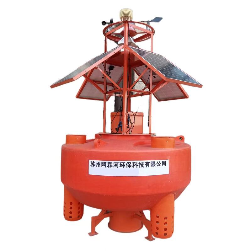
A drifting buoy measures its location at scheduled intervals and pairs that position with readings from onboard instruments. A GPS receiver records latitude and longitude, while telemetry may send data through cellular or satellite networks depending on the operating area. Battery capacity, transmission frequency, hull drag, sensor duty cycle, and expected recovery period determine the practical operating duration.
I use drifting buoys for surface-current monitoring, storm-track observations, pollutant or spill movement studies, fisheries research, network gap filling, and short oceanographic campaigns. Asenhe describes its Surface Drifter as a compact platform that follows surface currents while transmitting positioning and environmental data. Its ASH-432-A Wave Buoy is presented for offshore and open-ocean observation with long-endurance operation.
The central moored buoy vs drifting buoy difference is positional control. A moored buoy is designed to remain within a defined operational area, whereas a drifting buoy is designed to move through the water and document that movement. Neither platform is universally better; each produces a different type of evidence.
| Evaluation factor | Moored buoy | Drifting buoy |
|---|---|---|
| Position | Fixed near an anchor location | Moves with currents and wind |
| Primary dataset | Continuous time series | Trajectory-based spatial series |
| Coverage | One station or limited watch circle | Broad route or network area |
| Deployment | Requires anchor and mooring design | Requires release and tracking plan |
| Recovery | Planned retrieval or servicing | Optional, depending on design |
| Sensor capacity | Usually supports larger payloads | Limited by size, drag, and battery |
| Best use | Long-term stations and compliance | Current mapping and mobile surveys |
| Main risk | Mooring failure, fouling, vessel access | Loss, grounding, or uncertain route |
| Cost profile | Higher initial infrastructure | Lower deployment infrastructure, higher replacement exposure |
If I need a multi-year record from one coastal station, I select a moored buoy. A fixed-point dataset makes it easier to identify seasonal cycles, tidal patterns, storm effects, and long-term trends because the measurement location remains known. This is especially relevant for an ocean monitoring buoy carrying multiple sensors and transmitting records to a central data platform.
If I need to observe how water moves, I select a drifting buoy. Drifting buoy GPS tracking can reveal current direction, transport speed, retention zones, and the movement of a surface feature. The trade-off is that the buoy may leave the study boundary, pass into unsuitable waters, or produce data that are difficult to compare with a fixed station.
A moored platform normally provides stronger temporal continuity and easier data comparability. However, the measurement may represent only the water around one station, and a strong current can tilt the mooring or shift the sensor away from its intended depth. I therefore require mooring-line geometry, depth checks, calibration records, and biofouling controls.
A drifter offers stronger spatial representativeness when the mission concerns water movement across an area. Its trajectory fidelity depends on GPS interval, position uncertainty, windage, drogue depth, and the relationship between the drifter and the water layer being studied. A drifting buoy should not automatically be treated as a direct current meter because surface wind and wave forces can alter its path.
Deployment planning is the point where a theoretical comparison becomes an engineering decision. For a moored buoy, I calculate water depth, anchor type, line length, scope, tidal range, current speed, wave height, seabed conditions, vessel lifting capacity, and navigation clearance. Deep-water deployments require more line material, stronger connectors, larger anchors, and more vessel time, which can change the total budget substantially.
For a drifting buoy, I focus on release location, expected current direction, shipping lanes, shoreline hazards, weather windows, tracking coverage, and recovery probability. A low-cost drifter may be appropriate for a short campaign where recovery is not required, but the same design may be unsuitable for expensive sensors or legally sensitive monitoring. I also define a replacement plan before deployment rather than treating loss as an unexpected event.
Power demand depends on sensor count, sampling rate, processor activity, telemetry frequency, and environmental conditions. Asenhe’s listed 3-meter ocean buoy configuration includes a 12 VDC, 800 Ah lithium battery and solar options of either 480 watts using four 120-watt panels or 720 watts using six 120-watt panels. Those figures illustrate the scale of a fixed offshore platform, but actual autonomy must be calculated from local solar availability, battery temperature, load profile, and reserve requirements.
Telemetry affects both data continuity and operating cost. Cellular communication can be practical near the coast, while satellite transmission is more suitable for offshore or mobile missions with limited network coverage. I specify the required reporting interval, data packet size, local storage capacity, alarm rules, and fallback behavior before choosing the communication module.
Maintenance is usually more structured for moored buoys because the platform remains accessible at a known location. Planned service may include cleaning, sensor calibration, battery inspection, solar-panel cleaning, anode replacement, mooring inspection, and corrosion checks. Drifters reduce routine servicing but increase uncertainty around recovery, battery replacement, and physical loss.
Purchase price alone gives an incomplete comparison. For a moored buoy, I include the buoy platform, sensors, mooring hardware, anchor, deployment vessel, installation crew, permits, communications, servicing trips, retrieval, refurbishment, and redeployment. For a drifting buoy, I include the buoy, sensors, release operation, communications subscription, tracking, recovery vessel time, expected loss rate, replacement units, and post-mission data processing.
A simple five-year model can be structured as follows:
| Cost category | Moored buoy | Drifting buoy |
|---|---|---|
| Initial hardware | Platform, sensors, batteries, mooring | Buoy, sensors, battery, tracker |
| Deployment | Anchor installation and vessel operation | Release operation and tracking |
| Recurring service | Scheduled inspection and calibration | Usually limited or none |
| Recovery | Planned retrieval and redeployment | Possible, but not guaranteed |
| Loss exposure | Mooring failure or collision | Drift beyond recovery range |
| Communications | Cellular or satellite subscription | Cellular or satellite subscription |
| Best financial case | Long-duration fixed station | Short campaign or multi-unit survey |
A moored buoy often has a higher initial cost but can spread that investment across many years of measurements. A drifting buoy can reduce deployment infrastructure and cover more area, but the cost per usable dataset rises if units are lost, leave the study zone, or require frequent replacement. I compare the cost per valid observation, not only the cost per buoy.
Asenhe states that its source-manufacturer model can provide cost savings of 30% compared with comparable products. I would treat that figure as a supplier claim requiring project-specific confirmation, because final savings depend on payload, materials, communication method, mooring depth, testing, shipping, and installation scope. The same supplier reports more than 1,000 global projects, exports to more than 80 countries, 15 years of experience, multiple patents, and CE and ISO certifications.
Traditional drifting buoys are useful when the mission values low infrastructure and natural current following. Traditional moored buoys are useful when the mission values a stable station and continuous measurements. However, neither option is ideal when I need repeated mobile surveys, controlled routes, expensive recoverable instruments, or adaptive sampling around hazards.
In those cases, a recoverable mobile platform or return-to-home USV may provide a better operational fit. A mobile surface vehicle can follow planned waypoints, return for servicing, carry larger batteries, and reuse sensors across several campaigns. It may also reduce loss risk compared with a disposable drifter, although it introduces propulsion, navigation, maintenance, and regulatory requirements.
The correct comparison is therefore not always fixed buoy versus drifting buoy. For a research team conducting monthly transects, a recoverable platform may deliver more usable data over a year than multiple expendable units. For a one-week current study in open water, a drifter may still be simpler and less expensive.
| Mission condition | Recommended platform | Reason |
|---|---|---|
| One coastal station for several years | Moored buoy | Stable position and continuous time series |
| Short current-following campaign | Drifting buoy | Measures movement through the study area |
| Deep-water fixed observation | Moored buoy with engineered mooring | Supports controlled sensor depth and telemetry |
| Large-area surface-current mapping | Drifting buoy network | Multiple trajectories improve spatial coverage |
| High-value sensors requiring retrieval | Moored buoy or recoverable mobile platform | Better control over recovery and servicing |
| Port or harbor monitoring | Moored buoy | Fixed location supports alerts and compliance |
| Fisheries habitat movement study | Drifting buoy or mobile platform | Tracks water masses and changing conditions |
| Repeated survey routes | Recoverable mobile platform | Reusable equipment and controlled paths |
| Limited vessel access | Drifting buoy with satellite tracking | Less dependence on return visits |
| Multi-parameter offshore station | Moored ocean monitoring buoy | Supports larger power and sensor payloads |
I begin by writing the mission in measurable terms. The specification should state the target water area, measurement depth, parameters, sampling interval, reporting interval, deployment duration, acceptable position error, recovery requirement, and maximum vessel-access frequency. Without these values, supplier comparisons tend to focus on hull size or appearance rather than data suitability.
Next, I separate station measurements from transport measurements. Station measurements require positional stability, calibration consistency, and long-term power planning, while transport measurements require accurate tracking, trajectory interpretation, and sufficient mobile endurance. If both objectives matter, I may combine one moored buoy with several drifting units rather than forcing one platform to perform both roles.
Finally, I review the supplier’s engineering scope. Asenhe identifies itself as a technology enterprise integrating R&D, production, and sales, with customization covering parameters, materials, connection methods, sensor integration, communication systems, and structural adaptation. Its listed ocean buoy configuration supports optional water-quality sondes, weather sensors, wave sensors, current meters, GPS, chlorophyll sensors, satellite or 4G communication, LoRa, RS485, offshore mooring systems, and extended solar power.
Moored Buoy vs Drifting Buoy: Which Fits Your Monitoring Mission? The answer depends on whether the project prioritizes fixed-point continuity or moving-water coverage. I recommend a moored buoy for long-term coastal stations, port monitoring, offshore engineering support, wave measurement, and multi-parameter environmental records at a defined location.
I recommend a drifting buoy for current-following studies, surface transport research, storm observations, fisheries applications, and campaigns that need broader spatial coverage with limited anchoring infrastructure. When recovery, reuse, route control, or expensive sensors are central requirements, I would also compare a recoverable mobile platform or return-to-home USV.
For procurement, I would request a mission-specific quotation from an ocean monitoring buoy supplier such as Asenhe and require the proposal to separate hardware, sensors, mooring, communications, deployment, servicing, recovery, and redeployment costs. I would also ask for power calculations, position specifications, sensor calibration procedures, corrosion protection details, data-storage capacity, and a five-year total-cost model before selecting the final system.
Previous: None.
Next: How to Position Meteorological Sensors on an Offshore Buoy
Copyright:@2020-2021

Comments Please sign in or sign up to post.
0
0 of 500 characters used